10 Best Beaches in California (You Didn’t Know About) [2020]

There aren’t many things that go together as well as California and beaches. Sure, the dramatic tree-lined cliffs along the beaches in Washington and Oregon are some of the greatest stretches of coastline in the world, but the beaches of California are something else altogether.

The next ten beaches are some of the most amazing destinations you’ll ever experience along the California coast. From sunny Southern California to the foggy shores at the top of the Golden State, make sure as many of these sites as possible are on your next California itinerary, because the scenery and experience of this magnificent Pacific shoreline is one you will never forget.

Related: Ultimate Guide to Cleaning Seashells


Hospitals Reef Potholes (La Jolla, California)

  • Admission: Free
  • Hours: Open 24 hours
  • Pets: Not allowed during the day

Slabs pockmarked with little moon craters reflect the golden skies of a breaking sunset at Hospitals Reef, just outside San Diego. Scattered in the hundreds among the reef rocks, some of the deeper pockets harbor mini–tide pools, where small marine organisms can be found beneath the water’s reflection.

While photographers looking for unique landscapes to capture are the ones who normally linger the longest around these captivating coastal rocks, other visitors will also find the often-overlooked Hospitals Reef Potholes to be a unique and worthwhile attraction.

Photo by Wenjie Qiao.

The absolute best time to capture the mystique of Hospitals Reef is during sunset, where you will find plenty of compositions to experiment with. One of my favorite shots of the potholes is when the picture captures the sunset reflecting from puddles in the potholes. This usually requires hoisting your tripod a little higher than you might normally do, but it definitely makes for a one-of-a-kind photograph of the coast.

La Jolla Cove, right next door, is far from a hidden gem, but it’s the perfect place to spend your time waiting for the sun to come down before catching your best shots of the potholes. La Jolla Cove is one of the most popular coastal destinations in Southern California for swimming, snorkeling, and kayaking. Under the right conditions divers can explore dramatic underwater ledges and even catch glimpses of local lobsters.

Because the cove is protected from the surf, the waters are usually calm enough to make swimming possible. But even if you don’t want to get in the water, sunbathing next to the clear turquoise waters can be a heavenly experience. If you go during the summer season, however, just be prepared for crowds. The beachfront at the cove is very small and, if you want to secure a spot and get free street parking, plan on arriving early.

Tips

  • There are numerous restaurants and shops to visit in the La Jolla area.
  • During low tide, this site has some of the best tide pools around, so be sure to check them out.
  • You can often catch sea lions up close at the Children’s Pool.

Montana de Oro State Park (San Luis Obispo County, California)

  • Admission: Free
  • Hours: Open 24 hours
  • Pets: Not allowed on trails; must be leashed at Spooner’s Cove and at campgrounds

Montana de Oro, meaning “Mountain of Gold,” got its name from the golden wildflowers that blanket its hills and top the cliffsides. It’s a spectacular location for hikers, photographers, and campers looking for a combination of both beautiful hills and beaches to explore on any given day. The best part of all is that this beach is usually pretty quiet, and you’ll likely enjoy it without huge crowds.

Montana de Oro State Park. Photo by johndaciuk.

Photographers will want to head to Spooner’s Cove to get great photos of the renowned golden cliffs and pebbles that make up the smooth shores of this beach. Some of the rock formations on the beach have an interesting striated “wafer” appearance caused by years of wave-cut erosion, and there is also a beautiful natural arch rock formation jutting out from the coast.

In addition several rocks offer some good climbing and even better bird’s-eye views of the Pacific when you’re on top of one. And since the tide pools here are some of the best that the California coast has to offer, don’t forget to check the tides to catch this beach at low tide for some really great shots.

While roaming the intertidal areas of the coast, you might come across a bulky black bird with a long bright-red beak. Known to inhabit the shores along the entire western United States, this bird is known as the oystercatcher, and it forages among the tide pools in search of mollusks, isopods, and isn’t afraid to take on its fair share of crabs. It uses its strong beak to pry open the shells of its prey and usually hunts so close to the surf that it’s seen flying up and down just in time to avoid being swept up by oncoming waves.

Photo by Randy Robertson.

Hikers will appreciate the turquoise waters of the ocean at sea level, but they will likely be most interested in the hike up to Valencia Peak, which stands at over 1,300 feet above sea level. The hike is only 3.7 miles round-trip and not overly strenuous, so even inexperienced hikers should be able to manage the ascent (though be warned there is little, if any, shade on the trail). The best part about this hike is that you’re given wide 360-degree views of the ocean and the surrounding rolling green hills and canyons.

Take your time on your way up and down the hike to take in the views and, if you want to just stop and reflect and take it all in, then maybe even plan for a picnic as there are picnic tables along the trail to the summit. If such an ascent doesn’t do it for you, there are several other trails available for you to choose from in the park as well, such as the popular Bluff Trail, a 1.2-mile round-trip family-friendly trail that follows along the rugged coastline and takes you through tide pools.

Finally, if you are into mountain biking or even if you’re interested in just giving mountain biking a try for the first time, this is definitely a great place to do it. Beginners should consider trying the Islay Creek Road Trail or the Bluff Trail, while more ambitious or experienced cyclists can look into the Hazard Peak, East Boundary, and Oats Peak Trails.


McWay Falls at Julia Pfeiffer Burns State Park (Monterey County, California)

  • Admission: Depending on parking situation, free to $10
  • Hours: Open 24 hours
  • Pets: Not allowed

A thin waterfall spills eighty feet down onto the soft sands of this cove as another wave of turquoise water washes ashore. Just yards from the tree-topped rocks, a group of cuddly sea otters lie on their backs, bobbing in the surf. It’s a magnificent scene that stills the sands of time, and, when the glow of sunset illuminates the golden cliffsides, photographers flock to nearby overlooks to capture the magic of it all. McWay Falls, one of only two tidefalls (waterfalls pouring into the ocean) in California, is one of the biggest highlights of the central California coast and deserves a spot on everyone’s Highway 1 itinerary.

Photo by Chase McMunn.

One great thing about this location is that the trail from the parking lot to the overlook is just over a half mile long, so it’s easy to fit into your road-trip itinerary. There are two ways to access the trailhead to the overlook.

You can park along Highway 1 (for free) and start down the trail, or you can pull into Julia Pfeiffer Burns State Park and pay a fee. From wherever you parked, make your way to the main parking lot entrance of the park and you’ll see a sign for Overlook/Waterfall Trail/Pelton Wheel. From there, follow the well-maintained trail under the highway and then continue on, turning right until you eventually arrive at the overlook. And, if you have time to continue down the trail, there are numerous other scenic overlooks to check as well.

Any time of day will allow for exceptional photographs of McWay Falls, but catching the sunset here allows for a stunning contrast between the turquoise waters and the golden cliffs that you really don’t want to miss. So consider getting your photographs at sunset.

McWay Falls is remote and far removed from urban light pollution, so, if you’re adept at astrophotography, then certainly consider a night visit to these overlooks too. The coast is usually fogged over at night, but, if you catch it at the right time, you can capture some unforgettable scenes of the Milky Way or the moon illuminating the cove.

Tip

  • In order to keep the cove in its pristine condition (and to protect visitors from treacherous cliffs), the park service issues a $400 fine for those going down onto the beach area, so your best bet is just to admire it from a distance.

Pfeiffer Beach at Los Padres National Forest (Big Sur, California)

  • Admission: $10 fee per vehicle
  • Hours: 9 a.m. to 8 p.m.
  • Pets: Allowed but must be leashed

Pfeiffer Beach is small, secluded stretch of shoreline tucked away in the heart of the renowned Big Sur area of central California. It’s a special place, treasured (and practically guarded) by locals, and it’s also home to two spectacular natural wonders that, if caught at the right time, capture nature’s best intentions and mesmerize even the most disinterested observer.

One normally looks up to the sky and the clouds at sunset for those unique shades of purple best captured at the coastline, but, here at Pfeiffer Beach, you’ll find those same swirls and patches of pastel purples and blues shining back at you not from the sky above, but from the sands below as the cold waters of the Pacific wash over them.

The sands of the beach aren’t entirely purple, but, during damp conditions, especially after strong winter storms blow through the region, ripples and streaks of various shades of violet and pink lay out before you. These unparalleled colors are a by-product of the manganese garnet that’s eroded from the towering hills nearby.

Photo by Justin Dolske.

Pfeiffer Beach truly is a sight to behold, and, when extremely damp or soaked sand converges with seawater at the same time, it’s nothing less than life imitating art as the image laid perfectly before your eyes hits you like an abstract oil painting from the finest museum in the world.

The second amazing feature of Pfeiffer Beach is Keyhole Rock, a large rock formation with a seemingly perfect rectangular hole cut through the middle of it.

It’s a beautiful sight in and of itself, but the rock really becomes special about two weeks before and after the winter solstice when the sun falls beyond the horizon at just the right time so that sunsets literally burst through this golden doorway, casting brilliant hues of yellow and orange onto the rocky ridges and surrounding surf.

The effect is similar to the “firefalls” at Yosemite National Park and is one of the most highly coveted images for photographers.

Photo by Steven Christenson.

However, if your desires are to capture this magic like so many other photographers intend to do, you should plan on arriving early enough to set up your tripod and get a great spot. During those short couple of weeks when this phenomenon takes place, photographers flock here in the evenings, and things can become quite busy, which means parking can also be an issue.

And it’s probably not a bad idea to clarify some possible confusion regarding the number of “Pfeiffer” destinations along this part of the California coast. First, the name Pfeiffer comes from a German family that was one of the first to explore and settle in the Big Sur area.

There are three similarly named destinations often confused with each other. First, there is Pfeiffer Big Sur State Park, one of the most visited sites in California. This park is located just a couple miles north of Pfeiffer Beach. Second, there is Julia Pfeiffer Burns State Park, located roughly ten miles south of Pfeiffer Beach and home to McWay Falls, the previous destination. Finally, there is Pfeiffer Beach, a part of Los Padres National Forest, and home of the amazing Keyhole Rock and purple sands.

Tips

  • The parking lot at the beach is very small. If planning a visit during the summer, especially on a weekend, then make sure that you arrive early in the day to secure a spot.
  • Winds and currents at this beach are very strong. Check the wind forecast before you venture to the beach and either make sure you wear the proper attire or postpone your trip if winds are extremely bad. The way the winds can kick up out there, improper preparation makes for a less-than-fun experience.
  • For best results when photographing Keyhole Rock, attempt to arrive during a high tide when the waves are crashing through the hole for heightened dramatic effect.

Point Lobos State Reserve (Monterey County, California)

  • Admission: Depending on parking situation, free to $10
  • Hours: Open 24 hours
  • Pets: Not allowed

Point Lobos, consisting of two different state reserves and a marine conservation area, is one of the crown jewels of the California coast. It’s one of the best places in California to come and take a few short strolls (less than one mile) and see a number of stunning rocky beach coves with clear turquoise waters and a diverse range of marine animals, such as sea lions and seals.

Point Lobos State Reserve. Photo by Steve Alexander.

Offering some of the most visually stunning beach coves along the California coast, Point Lobos is rife with wildflowers and rare vegetation, and presents a variety of short and easy hiking options. With so many different trails to explore, it can be hard to narrow down your choices, but here are two of the top routes that you might want to consider. They are both short and could easily be done together on a half-day visit along with a couple of the other shorter trails in the park.

One of the top trails at Point Lobos is the Cypress Grove Trail, a .8-mile trail that takes visitors through an array of coastal scrubs, as well as some of the most spectacular cliff overlooks you’ll find in the area. Perhaps most fascinating about this trail is that it winds through one of the two naturally growing strands of Monterey cypress trees.

Cupressus macrocarpa, also known as the Monterey cypress, once populated a much wider area, but, as the climate changed over 15,000 years ago, their population has dwindled. Remarkably the only other place on the face of the Earth that these rare trees can be found is at Cypress Point, across Carmel Bay. Other interesting sights along this trail include California sea lions, sea otters, and perhaps even gray whales migrating during the winter and early spring.

Another great option to make time for is the Bird Island Trail. Fully accessible, this trail is also only .8 mile round-trip and brings visitors through pine forests, coastal scrubs, and rocky cliffs. This trail winds through two spectacular beaches, including one of the most scenic spots in all of Point Lobos: the exquisite China Cove, with its white sands and sparkling emerald waters.

In the spring, China Cove is home to barking harbor seals where they nurse and comfort their newborn pups. The beach is closed during this time, but, at all other times of the year, the reserve allows visitors to take a dip in the bone-chilling waters.

While you really can’t go wrong with these hiking options, as well as those at Point Lobos, the diving sites at the reserve are something else that should be considered for those skilled enough to do it. Without question, Point Lobos is one of the best diving destinations along the entire California coast. From Whalers Cove, the diving options extend across the valleys and boulders of a rich underwater seascape where canopies of lush kelp forests can be explored in the company of seals and sea otters.

More adventurous divers can explore the undersea world at Bluefish Cove, where many experienced divers remark that the waters are clearer and the wildlife even more diverse. The waters of Bluefish Cove are not protected from the full force of the open ocean, resulting in waters that are richer in nutrients and reef life that’s four times the density of other dive areas.

Everything from sea lions and molas (the strange bloblike sunfish) to massive swarms of jellyfish, sharks, and whales can be spotted at Bluefish Cove. Regardless of where you dive, however, all marine animals are fully protected, so visitors can experience the full array of mature marine animals that aren’t as shy in approaching divers. Prepare yourself for an unforgettable diving experience, and be sure to check with park administrators to secure the necessary diving permits.

If diving in the cold kelp forests at Point Lobos sounds a bit too adventurous for you, or you are simply interested in learning more about this fantastic natural reserve, then consider a visit to the Whaling Activities Museum as an alternative.

The museum tells the story of the whaling industry that existed at Point Lobos in the 1800s, when Portuguese whalers hunted gray whales and used their blubber to manufacture whale oil, also known as “train oil” that was used for lamps, as well as to make soap and margarine. At the museum there are a number of exhibit panels describing the lives of these whalers, along with old “try pots” which were the pots used to boil the whale blubber.

Tips

  • Binoculars can be rented from the information station at Sea Lion Point for better wildlife watching.
  • Weekends can get quite busy, especially during the summer. Arrive before 9 a.m. to secure parking. Otherwise, you will have to park on the highway and deal with a long, nearly two-mile walk to the park.
  • September and early October may be the best time to visit because of the cooler weather in those months, but many of the coves are at their clearest after winter storms have blown much of the kelp from the water.

Shark Fin Cove (Davenport, California)

  • Admission: Free
  • Hours: Open 24 hours, though parking is limited to 6 a.m. to 10 p.m.
  • Pets: Allowed

Shark fins rising from the ocean don’t typically entice visitors to come visit the coast, but this place is the exception. Here a menacing dorsal-shaped sea stack provides the dramatic centerpiece for a scenic cove surrounded by deep inlets and alcoves. From atop the white bluffs, or through the shadowy windows of one of the sea caves below, you can admire this stunning by-product of erosion that’s earned this beach its name, Shark Fin Cove.

Photo by Sudheer G.

If you wish to venture onto the sands at Shark Fin Cove, be prepared; the walkway down onto the beach is a little steep and slippery, meaning good shoes and a little bit of shimmying skills will be needed. In addition to the stunning rocks and cliffs, the beach also has some of the softest beach sand that you’ve probably ever stepped foot on.

I’m not sure what causes the extreme softness in the sand though I’m certain it’s due to some kind of special erosion and perhaps a high percentage of quartz (versus pulverized coral) that takes place in the cove. After you make it down to the beach, be sure to take off your socks and shoes so that you can sink your feet into this wonder sand.

Also take some time to explore one of the many sea caves located in the cove. Just be very careful when approaching the shoreline in the cove or anywhere even remotely within reach of the cove’s powerful waves. The position of this beach just happens to be where waves often converge, causing volatile rogue waves that are a real and frequent hazard at Shark Fin Cove. The most beautiful landscapes often offer a degree of danger at the same time, so remember to keep your eyes and ears on the waves, and you’ll be fine.

Tip

  • If you’re looking for a bit more room to roam, then just head up the coastline to Davenport Beach for a more spacious setting.

Bodega Bay (Bodega Bay, California)

  • Admission: Free
  • Hours: Sunrise to sunset
  • Pets: Allowed

In between the loud crashing waves, you hear the distant barking seals. Not sure where the sound is coming from, you scan the horizon until you notice a small rocky island with a cluster of tiny black silhouettes perched comfortably. It’s Seal Rock, home to hundreds of seals, and it’s just one of the many extraordinary sights you’ll come across at Bodega Bay, one of the best-kept secrets of Northern California.

At Bodega Bay, trails wrap around green headlands, climb up cliffs perfect for whale watching, and drop down steep bluffs onto secluded beaches where you’ll be the only human being walking on the sand. It’s a special place and one that demands at least half a day to appreciate.

One of my favorite things to do at this place is to just make the easy hike up to the tip of Bodega Head and look out from the cliffs into the ocean. It’s the best place for whale watching in the area, and it’s a perfect place to relax and watch the waves crash into the rocks beneath you. From January to May on every Saturday and Sunday from noon to 4 p.m., you can catch a group of volunteers at Bodega Bay to assist you with your whale watching.

If you’re more of an adventurous traveler, then consider scrambling down a steep bluff onto a secluded beach. As you make your way along the coast near Bodega Head, you’ll notice a skinny trail leading down a cliff and into a small cove. The trail eventually disappears and becomes a steep scramble, so, if you’re not confident in your ability to hoist yourself up a rocky cliffside, you may not want to venture there. But if you can make it, you will be rewarded and have an entire beach area to roam, usually not accompanied by other people.

Even if you’re not up for a little bit of climbing and scrambling, there are still plenty of trails to enjoy a pleasant walk and admire the views. Try walking along the trails on the coastline heading south. In the spring, these trails are full of beautiful wildflowers, and, while you’re enjoying those sights, you’ll likely hear the bark of seals from the distant Seal Rock. If you have binoculars, you’ll be able to catch a glimpse of hundreds of seals sprawled out over a small rocky island.

Other attractions here are the tide pools and rocky beach areas. I encourage everyone going to Bodega Bay to do their best to catch a negative tide, because there are ample opportunities to hop around the rocks and tide pools. Hundreds of jagged rocks—some coated in beautiful clusters of gooseneck barnacles and shiny black mussels—are great to climb, and it’s a lot of fun to wade into the cold saltwater pools and see what kind of creatures you’ll find.

You will normally come across giant green sea anemones, and sea stars made of bright purple and orange colors, but you never know what other exotic sea creatures might be hiding beneath the layers of slimy green algae. Chances are, you will stumble across something interesting. I’ve provided a link to the tide schedule, so you can take a look, see the dates and times when the next negative or very low tide will hit.

While the beach is in Bodega Bay, the nearby town of Bodega Bay is also worth stopping by. You’ll find little shops and restaurants in this antique town full of rich cinematic history. If one of the buildings, a schoolhouse, looks somewhat familiar to you, that’s because it’s the same schoolhouse used in Alfred Hitchcock’s famous movie The Birds.

If time is not an issue, you might also consider stopping at a number of other beaches north of Bodega, including Schoolhouse Beach and Goat Rock Beach (where you can view the backdrop from the last scene of the movie The Goonies).

These beaches are found along Sonoma State Park, an area of the coastline just north of Bodega Bay that is home to many beautiful beaches that don’t disappoint. Many of these beaches are not heavily visited, giving you a good chance when you arrive of not having to deal with the hustle of big crowds. Best of all, I can’t emphasize enough how easy and enjoyable it is to just cruise down picturesque Highway 1, pull over and walk down to the beach for a while before moving on to the next one.

Tips

  • Be prepared for potentially windy conditions. Like most beaches in Northern California, the wind can be pretty harsh.
  • The beaches in this area are home to strong currents and surf, and the waters are not made for swimming.
  • There are numerous local restaurants in the Bodega Bay area that offer great seafood. Take your pick. You really can’t go wrong with any of them.

Bowling Ball Beach (Point Arena, California)

  • Admission: Free
  • Hours: 24 hours
  • Pets: Allowed, but keep leashed

Hundreds of brown balls, ranging from three to six feet in diameter, line up in rows along the shore. With sand stripped from their round bases, they huddle together completely exposed. In the distance, waves wash onto a green algae-covered platform, exactly where you had hoped because you’ve arrived at low tide—the perfect time to explore these “bowling balls” and the rest of the geologic marvels found among the bluffs at Bowling Ball Beach in Point Arena, California.

Photo by zug zwang.

From dinosaur eggs to visitors from another world, there has been much speculation over the years as to the source of these incredible formations. However, the truth is slightly less exciting. These massive spherical rocks are made up of sandstone and were formed when mineralized water seeped into the layers of sandstone sediments, causing these masses to harden.

Because these masses were much harder than the surrounding sandstone and mudstone cliffs, they didn’t erode in the normal fashion with the sediments in the cliffs and gave rise to the unique formations we see here today. Oftentimes these balls are formed around a nucleus, such as fossils, shells, or even leaves, so it’s likely that many of these concretions are housing all sorts of hidden objects (but don’t go cracking away at these things).

As interesting as these endless rows of bowling balls are, there’s more to this beach than that. Keep walking north along the beach, and you’ll see soon-to-be bowling ball concretions still lodged partially in the cliffs. Another site to explore is a large exposed bed of sandstone and shale called a “hogback” that protrudes from the sand surface like the side of a sunken ship. If you examine the hogback close enough, you’ll notice small tracks made from organisms that once lived among the sea floor.

Other fascinating formations can be found farther north along the beach. There are a series of large yellow concretions that appear glued to the cliffside like large circular refrigerator magnets. Unlike the bowling balls, these rock forms actually lie within a bed of shale, and some of them have been so far eroded that they have slid down the cliff and now rest comfortably on the ocean shore.

Finally another thing to see are the striations that run vertically along the cliffs and then stretch across the wave platforms on the beach. These rows of ridges and linear marks are made up of sandstone and were eroded by the constant force of wave action over millennia. If you examine the cuts, you’ll notice that the lines can be traced from the beach floor all the way to the bluffs’ own lines, which appear to correspond. Some of the bowling balls lie within these lines, leading many observers to refer to the lines and cuts as “bowling lanes.”

To make the most of the experience, it’s important that you time your trip for a low tide or, better yet, if you’re able to do it, catch a negative tide. At high tide, the bowling balls will be covered by the ocean, and some parts of the beach might not even be passable.

Tip

  • For photographers, this beach offers great opportunities to play around with the “slow shutter” effect as the tide moves in and sweeps through the concretions.

Glass Beach (Fort Bragg, California)

  • Admission: Free
  • Hours: Sunrise to sunset
  • Pets: Beaches vary; check signed posts.

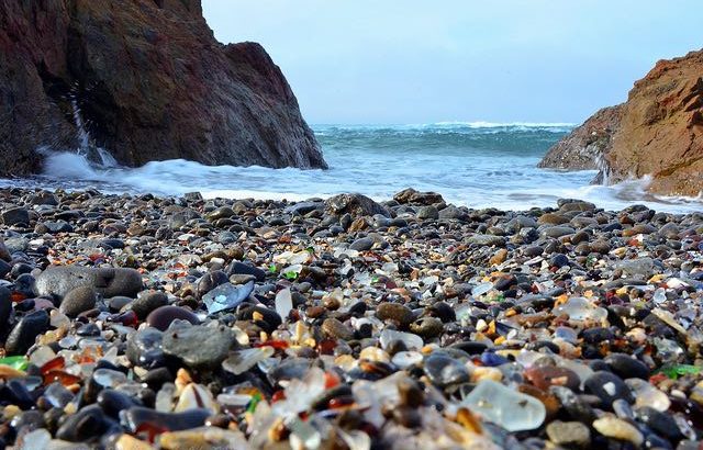
Thousands of tiny polished glass pieces glisten along the shoreline at Glass Beach, a part of MacKerricher State Park near Fort Bragg. Like rubies and emeralds, these treasures shine brightly among the beds of black and gray pebbles in which they lie. It’s a sight to behold—and one that’s been in the making for decades, albeit not always intentionally. Glass Beach, boasting the highest concentration of sea glass in the world, is a great example of nature overcoming man’s folly to create something wondrous and renowned.

Photo by Images by John ‘K’.

Unlike the scenery, the history of Glass Beach is far from glorious. It started when the 1906 earthquake that destroyed San Francisco also destroyed Fort Bragg, leaving massive amounts of waste to be disposed of.

To rid the streets of this waste, locals turned to ocean dumping and, unfortunately, continued doing so for decades. From the early 1900s until 1967, garbage consisting of everything from automobiles, batteries, appliances, bottles, and cans were thrust over the cliffs into the Pacific Ocean.

This wasn’t just a local practice but was, in fact, done frequently at other sites along the coast—a scandalous activity that still takes place in less developed parts of the globe. Luckily this dumping eventually became illegal and cleanup programs were initiated to remedy all the damage that had been done to the shore but not before tons of glass tumbled into the ocean.

Thousands of pounds of glass deposited here on this once-pristine beach were eventually broken down by the ocean and, over time, polished by waves, resulting in the beautiful smooth pebblelike appearance that the sea glass pieces possess today. The glass can be found in all different shapes, sizes, and colors.

There’s an old myth that, every time a sailor drowned at sea, a mermaid would cry with teardrops in the form of sea glass (“mermaid tears”), which then washed up on these coastal shores. Whether or not you buy into the poignant legend, you can’t deny the uniqueness of being able to wander through a beach covered in thousands of pieces of shiny greens, purples, and reds.

All visitors should know that removing any pieces of glass from any of the beaches is against the law. These beaches have been overharvested by visitors and glass collectors over the years to the point that the resources have nearly been depleted in some parts.

Add in the fact that erosion is steadily removing these pieces from the shore, and you can see how it would be necessary to prohibit visitors from taking away these precious glass pieces. Still, visitors are encouraged to “glass hunt” while they visit the beach and to collect as many different colors as possible so long as they put the pieces back at the end of their visit.

For those who are truly fascinated by sea glass, they should check out the Sea Glass Museum, located just south of Fort Bragg. It’s free to enter, and the museum has collections of all the different types of glass that can be found along the shores.

Tips

  • One of the most interesting times to visit is on Memorial Day weekend, when the annual Glass Festival is in town.
  • Glass Beach is also home to several endangered indigenous plants, such as the Menzies’ wallflower.

Trinidad State Beach (Trinidad, California)

  • Admission: Free
  • Hours: Sunrise to sunset
  • Pets: Allowed but must be leashed

Pewetole Island, topped with towering Sitka spruce trees, stands just offshore like its own little wilderness. While picturesque, this unassuming sight doesn’t initially strike you as anything out of the ordinary; however, your opinion soon changes.

As the tide picks up, a large wave rolls toward an outcropping of jagged rocks at the island’s base, smashing into the rocky shores and shooting a column of water through a natural blowhole, casting sea spray high into the air above the treetops. It’s a rare force of nature that plays out before your eyes, and yet it’s just one of the many reasons to put Trinidad State Beach on your itinerary.

Photo by Scott Jungling.

Part of the 2,300-acre California Coastal National Monument that was created by proclamation under President Bill Clinton in January of 2000, Trinidad State Beach offers visitors numerous beaches surrounded by towering redwoods, endless tide-pooling opportunities, and rugged sea stacks (vertical rock formations) that loom in the distance.

This federally protected beach location is made up of a number of different beaches and coves with extremely scenic views and panoramic vistas of the California coast. With so many worthy beaches and coves to choose from, it’s not easy trying to prioritize your itinerary in an area such as this, but my recommendation is to head over to College Cove at low tide to gain the best access to Pewetole Island.

College Cove is one of three beaches at Trinidad that can only be accessed via “Scenic Drive” and requires a bit of a hike to get to. The path down to the cove is very steep, although there are stairs to help navigate your descent. For those in decent shape and not afraid of some steep terrain, it shouldn’t be much of an issue (see the directions below for more information on getting there).

All around the beach at College Cove there are sea caves, cliffs, and rocks to climb and explore, not to mention plenty of vegetation—including massive redwoods that offer plenty of shade. In the spring, the headlands and cliffs are filled with bright wildflowers that inundate the surrounding area. Another great thing about College Cove is that it serves as a refuge from the winds, and, if you’ve ever been stuck on a Northern California beach on an extremely windy day, you know how nice it is to be able to find some shelter from the natural elements.

As a side note, I should mention that clothing is optional at College Cove, although it seems that those who prefer to bask in their birthday suits are usually in the minority. The nude section of the beach is actually barricaded by rocks and forms its own separate cove to the south, so, for those who do want to bare all, there is some degree of privacy. Also your initial arrival point at the beach is the northern cove, so, if nudity makes you a bit squeamish, you don’t have to worry about passing through that area.

As mentioned earlier, what’s really great about this beach is Pewetole Island, a small tree-covered island that stands just off the coast like a small, lonely wilderness. It’s topped with Sitka spruce trees, which are found along the Pacific Coast from Northern California all the way to Alaska.

These trees can grow to be massive and are one of the few species of trees capable of growing to three hundred feet tall. Sometimes these trees growing close to the ocean undergo an unusual growth process and sprout “burls,” which are spherical growths along their trunks that resemble tumors. Though they don’t affect the tree’s growth, they are an odd sight to behold.

During very low tide you can actually walk out to Pewetole Island and explore it. You must be careful doing this, however, because the tide will leave you stranded if you don’t keep an eye on it as it moves back in. Another impressive sight to see at the island is the blowhole.

Located toward the rear of the big island rock, the blowhole can only be seen from College Cove, and it appears when the surf is just right, causing water to explode through a small rock passageway in the island. When it happens, it leaves most people astonished at how high the water soars when it blasts through the rock.

In the Trinidad State Beach area, there are plenty of other more accessible beaches to choose from as well. Old Home Beach, just south of Trinidad Village, is a great choice if you are bringing along children, as it’s protected from strong surf and winds.

The trail down to Old Home Beach (sometimes listed as “Indian Beach”) takes you through some beautiful redwood areas known as “The Ancient Yurok Village of Tsurai.” This is a sacred site to the Yurok people, so be respectful as you make your way through, and be sure to stay on the trail.

The trail does take you over two hundred stairs, so it’s moderately challenging but well worth the energy. From Old Home Beach you’ll be able to see all the amazing sea stacks and large rocks off in the distance, such as Camel Rock.

Finally, if you’re interested in spectacular views, then be sure to visit Trinidad Head, where you’ll not only take a short hike that provides you with sweeping views of all the coves but you’ll also have the chance to spot gray whales off in the distance.


Final word

As you can tell, there are many more beaches to visit in California other than the popular beaches you find outside of Los Angeles. You may have heard of some of these beaches but chances are that a few of these are new to you If you are coming from somewhere outside of California.

2 comments

  1. Thanks for sharing. I appreciate you sharing this information. Great little get away itinerary. I have saved your article for future use!

Leave a Reply

Your email address will not be published. Required fields are marked *